Governance
In the context of this guide, governance barriers are those related to the organizational aspects and administration of work to address sea level rise. Governance barriers include a lack of leadership; unclear definition of roles and responsibilities; a siloed work environment; an unaccommodating institutional framework; a lack of awareness or understanding of the issue; competing timeframes and scenarios used to make decisions; legal uncertainty; competing priorities; opposing approaches to address the problem; and rigid regulatory and policy measures or a lack of necessary policy measures. The cross-cutting and "super wicked" nature of climate change exacerbates the governance barriers and challenges already seen within the water sector (Levin et al. 2012).
The organizational structure of a utility (e.g., units and divisions) is shaped by the services provided, and staffing needs are often based on meeting "level of service" goals and fulfilling regulatory obligations. There is often no regulatory driver for climate adaptation, so addressing sea level rise may not be assigned to a particular unit or staff person—nobody “owns” the issue. Staff may be concerned about sea level rise but feel overwhelmed by the issue on top of their established tasks, or they simply may not have the tools or expertise to address it.
Sea level rise adaptation solutions need to be scaled appropriately and are best addressed in a regional, holistic manner. This introduces another challenge: broad collaboration and communication with the right stakeholders. This may mean working with different units and administrative levels within your organization as well as coordinating/partnering with outside stakeholders, including other city departments and agencies, regional planning groups, community members, the private sector, and local, state and federal government. For example, if a water utility is interested in protecting a facility from coastal flooding, the ideal adaptation solution would provide multiple benefits across various sectors; leverage resources; and simultaneously protect other critical facilities, city-owned infrastructure, businesses, and neighborhoods in the vicinity. Aligning priorities and timelines, performing assessments, conducting outreach, developing designs, obtaining permits, and securing funds for a coastal adaptation project at this scale is extremely challenging and requires extensive coordination.
The following leading practices are in the action area of GOVERNANCE and are described below:
- Internal staff capacity needs to be a core investment strategy for sea level rise adaptation. Develop guidance, tools, and policies to empower your colleagues and ensure that climate change information is used in the work they do.
- Consider broad social and regional consequences that result from government decisions, policies, and programs and attempt to anticipate unintended and unexpected consequences.
- It is easy to get stuck in analysis paralysis – be prepared to spend as much time, or more, on developing an implementation and funding plan as you did on identifying vulnerabilities and assessing risk.
- Have assessments and action-oriented recommendations ready before the next extreme event and make sure that risks and adaptation projects are included in local hazard mitigation plans.
- Look for innovative ways to coordinate across departments and work with communities, such as a Joint Benefits Authority, to leverage resources, align funds, and aid project coordination.
- Leverage regulatory tools to limit or avoid further development on land that is vulnerable to sea level rise and encourage nature-based solutions with multiple benefits.
- Collaboration across jurisdictions, different levels of government, departments, and stakeholder groups will be required to address the complexity of large coastal protection projects/efforts and bring independent priorities into alignment.
- Consider private-public partnerships as a way to share costs and risk.
- For large-scale coastal protection projects, anticipate implementation challenges such as permitting and long-term maintenance agreements, and work with stakeholders and regulating agencies as early in the process as possible to work towards solutions.
The examples in this section include icons depicting when they represent stormwater, drinking water, or wastewater utilities.
Internal staff capacity needs to be a core investment strategy for sea level rise adaptation. Develop guidance, tools, and policies to empower your colleagues and ensure that climate change information is used in the work they do.
The internal capacity of agency staff to advance sea level rise adaptation needs to be strengthened and supported by leadership. This may entail hiring new staff to focus on climate adaptation, investing in new tools or training for existing staff, or acquiring contracts with consultants to support internal efforts. Climate adaptation planners can make it easier for their colleagues by directly engaging with operators, engineers, and managers and providing climate adaptation tools and information relevant to their tasks and deliverables. Staff can further be exposed to climate topics through external speaker presentations, working groups, and increased discussions with climate experts internal and external to the utility. While investments to build internal capacity will require dedicated funds, they are the first–and arguably the most important–step an institution can take to build resiliency.
The Philadelphia Water Department (PWD) recently adopted a policy requiring the use of Climate-Resilient Planning and Design Guidance. The guidance, which was developed by PWD's Climate Change Adaptation Program, equips staff with the tools and climate information necessary to mainstream the best available climate science into existing plans, projects, programs, and standards. Implementation of the guidance will ensure staff builds resiliency into the work they do to maintain, upgrade, and replace PWD drinking water, wastewater, and stormwater infrastructure. To fully empower staff to use the guidance, it was necessary to develop and adopt a department-wide policy. Building the case for guidance implementation and adoption of a policy involved years of internal outreach and education, including climate 101 presentations, listening sessions, sending resources from trusted voices (e.g., American Society of Civil Engineers guidance), and working with identified climate champions to internally build support, while stressing the importance of thoughtful communication and outreach strategies.
The Portland Water Bureau (PWB) in Oregon recently created a 5-year Strategic Plan that identifies climate change as a key priority and builds on a legacy of over 20 years of planning for climate change by the utility. However, "mainstreaming" or integrating climate change adaptation and planning throughout the water utility has been challenging over the years given the size of the organization, the different functions of work groups, and competing priorities. To address this challenge, the agency has invested resources over ten years to build internal staff capacity for climate change modeling and adaptation, including developing a specific Climate Resiliency Planning Manager position and hiring a Water Resource Modeler. These staff work with engineers and operators in the utility to provide resources and tools to help incorporate climate change information (including sea level rise, flooding, extreme heat, and drought) into engineering planning, asset management, facility/system operations, and water resource planning. The organization also established a set of Director’s Climate Commitments to further embed climate change into the daily work of the utility and specific projects, including a commitment to "integrate meaningful climate analysis into engineering project planning".5
![]()
Consider broad social and regional consequences that result from government decisions, policies, and programs and attempt to anticipate unintended and unexpected consequences.
Certain actions may incite public backlash and disengagement, exacerbate existing inequities, cause displacement of residents, or transplant a problem to a different location (e.g., building a seawall in one location could make flooding worse in another area). To avoid unintended consequences, engage professionals and stakeholders from diverse organizations and agencies to understand their values and concerns and strive toward clear communication on priorities, benefits, and goals.
Sea level rise can reduce the effectiveness of a drainage system as higher water levels cover outfalls and make it harder for water to flow from the system under the force of gravity. Sea level rise in combination with extreme precipitation events (e.g., heavy rainfall due to hurricanes) and especially high tides (e.g., king tides, storm surge during hurricanes) further exacerbates this issue, causing flooding inland as excess stormwater has nowhere to go. Flooding can also result from the stormwater infrastructure itself and act as a conduit for seawater backflow through street drains. With sea level rise, groundwater levels also increase and can breach the ground surface in low-lying areas, thus further exacerbating these infrastructure-related flooding issues. As neighborhoods get inundated and runoff flows over land, it picks up and transfers pollutants (e.g., fertilizer, pesticides, nutrient inputs, vehicle oil, as well as human and animal waste). These pollutants can impact the well-being of residents and ecosystems in coastal cities—especially marine and freshwater ecosystems if the pollutants make their way into receiving waterbodies (e.g., bays, estuaries, and coastal zone). The influx of pollutants into local waterways can reduce water-based recreation due to residents' health and safety concerns, impacting the local tourism economies and quality of life. The ecological impact of these pollutants can include large fish kills, algal blooms, loss of seagrasses, and their potential ingestion by endangered or threatened species.
Miami-Dade County, Florida experiences these flooding issues as "sunny day flooding" on a regular basis when there are large tides (e.g., king tides), even in the absence of storm events. To address chronic flooding in neighborhoods, in 2017–2018 the City of Miami Beach elevated streets and installed 70 one-way stormwater pumps in low-lying, flood-prone areas. These efforts were successful at reducing flooding from neighborhoods, but the pumping had the unintended consequence of adding pollutants and degrading the ecosystem in Biscayne Bay. To address this ongoing issue, the Miami-Dade County Division of Environmental Resources Management (DERM) and the City of Miami Beach enacted several measures to mitigate the negative impacts of runoff on the Bay, including adopting new fertilizer ordinances, establishing a local task force, investing in stormwater innovation projects, and public outreach initiatives (Jaramillo 2022; Miami-Dade County 2022a; Miami-Dade County 2022b). Additionally, as of 2020, the City of Miami Beach modified pump outfall designs to include dissipator boxes, initiated a $133 million sanitary sewer upgrade program, and created an environmental inspection program with the goal of reducing sewer overflows and construction run-off (City of Miami Beach 2021).
![]()
It is easy to get stuck in analysis paralysis – be prepared to spend as much time, or more, on developing an implementation and funding plan as you did on identifying vulnerabilities and assessing risk.
Do not spend all of your sea level rise adaptation planning time and resources on modeling, vulnerability assessments, and outlining potential strategies. Invest an equal amount of time, or more, in developing an implementation plan that includes design and construction timelines, permits and regulatory requirements, and funding mechanisms (e.g., capital planning budgets and grant opportunities).
![]()
Have assessments and action-oriented recommendations ready before the next extreme event and make sure that risks and adaptation projects are included in local hazard mitigation plans.
Unfortunately, it often takes an extreme event for local political leaders and decision-makers to understand the risk that extreme events and climate change pose. Therefore, having plans ready for implementation that could be quickly adopted following a disaster is a smart approach. Ensuring that climate risks are acknowledged and projects to address them are included in local hazard mitigation plans is an important step for accessing federal funds. For example, after an event has a Presidential disaster declaration, the Federal Emergency Management Agency’s (FEMA) Hazard Mitigation Grant program can be used to implement projects that reduce the impact of climate change, such as drought, coastal erosion, and flooding, but only if those risks and mitigation projects have been specifically identified in the local hazard mitigation plan.
![]()
Look for innovative ways to coordinate across departments and work with communities, such as a Joint Benefits Authority, to leverage resources, align funds, and aid project coordination.
A Joint Benefits Authority (JBA) is being tested as a mechanism to bring multiple city departments together in partnership with communities to develop infrastructure projects that address climate change and build community resilience. Traditionally, it is challenging to work across departmental silos and with the community on large-scale projects that require coordinated objectives, timelines, and funding. Ownership and maintenance issues are also constraints for collaborative projects that provide multiple benefits. The creation of a JBA that can issue bonds and align them across agencies can then address barriers that separate agencies and departments and help them work more easily with the community. The JBA establishes a mechanism for joint funding, accountability, strategy development, monitoring, implementation, and community partnership. The JBA tool is being piloted in San Francisco and was developed by the World Resources Institute with partners, including the San Francisco Public Utilities Commission.
![]()
Leverage regulatory tools to limit or avoid further development on land that is vulnerable to sea level rise and encourage nature-based solutions with multiple benefits.
Coastal and land use regulations that limit or prohibit development in the coastal zone can reduce flood risk to communities that are vulnerable to sea level rise. Some examples of regulatory tools include land-use zoning overlays6 that impose additional resilience requirements on development in coastal areas or limit development altogether; set back or buffer requirements that prohibit development a certain distance from a baseline (e.g., high tide mark); floodplain regulations that add a safety factor to account for sea level rise; or regulatory incentives that provide co-benefits, such as living shoreline solutions to protect private properties over engineered built solutions such as a bulkhead. Regulatory tools can come along with pushback from the development community and complex legal considerations specific to the given area, so it is important to understand the political and legal frameworks in place when exploring the adaptation strategies available.
In 2011 King County, Washington, initiated an update to its floodplain mapping and development standards to protect structures and communities along its shorelines from the impacts of sea level rise. The County included sea level rise projections in an assessment of its existing FEMA 100-year floodplain boundary and proceeded to incorporate sea level rise into its coastal floodplain building regulations (FEMA-designated flood zones). This code change became known as the Sea Level Rise Risk Area and extends the edge of the regulated floodplain boundary inland until the land intersects with +3-feet above the 100-year base flood elevation (BFE) for that location. The areas within this extended floodplain have the same code requirements as the mapped FEMA 100-year floodplain. The width of the Sea Level Rise Risk Area is not uniform and varies due totopography. Structures built in the Sea Level Rise Risk Area (those that go beyond the boundary of the FEMA 100-year floodplain) do not have to carry FEMA flood insurance because they are not located in the FEMA designated zone. However, they are required to be +3 feet above the BFE and pass engineering specifications required by the County. Additionally, no new groundwater wells are allowed to be installed in the existing 100-year floodplain, and if a building is located on a bluff, the setback requirements were changed from 50 feet to 75 feet unless a geotechnical study is completed to prove that a structure is not prone to sliding. The code change and related policies are only applicable to Vashon-Maury Island, which is an unincorporated area where King County acts as the local government.
The County code change and resulting FEMA floodplain maps officially became effective in 2020 with the adoption of the County’s 2020 comprehensive plan update. This update included a series of public meetings and engagement efforts, and the County walked through sea level rise concerns and proposed regulations with the Vashon-Maury Island community. The County is working on implementing and communicating the new code changes to developers and property owners and has created parcel reports to view the boundary limits and better visualize the new requirements. The updated code was adopted unanimously with no public objection. The County attributes this in part to the fact that the new regulation only covers new development and major remodels. The Vashon-Maury Island shoreline is already very developed with limited new space, so many property owners were not greatly impacted by the change. King County’s new code regulation has the highest BFE requirements in the state.9
![]()
Collaboration across jurisdictions, different levels of government, departments, and stakeholder groups will be required to address the complexity of large coastal protection projects/efforts and bring independent priorities into alignment.
In most places, there is no centralized agency responsible for addressing sea level rise or other climate change risks, which makes collaboration and partnerships essential for aligning priorities, leveraging resources, and holistically advancing resilience. The larger the project, the more important stakeholder engagement is to ensure coastal adaptation solutions are considered across sectors and agencies with co-benefits for the community. For example, strategies to prevent or limit storm surge impacts may require careful consideration of the drainage network to ensure it can function properly during flooding events. Creating an avenue for communication between agencies and community organizations/members ensures that solutions will work for all parties and can lead to multi-benefit solutions, build synergies between projects, and establish an orchestrated output of adaptation action in sea level rise risk areas. These large-scale coastal protection projects can be complex, extremely costly, and require regional coordination.
San Francisco, California's Ocean Beach Project is an example of multiple city, state, and federal agencies collaborating to develop and implement adaptation strategies to address sea level rise, coastal erosion, and flooding. Several implementation projects are underway, including the Ocean Beach Climate Change Adaptation Project led by the City and County of San Francisco and the San Francisco Public Utilities Commission with support from the San Francisco Municipal Transportation Agency, the San Francisco Recreation and Park Department, and the Army Corps of Engineers.
The project will implement concepts developed in the 2012 Ocean Beach Master Plan which outlines the challenges sea level rise will bring to San Francisco's Ocean Beach and recommendations for how to address these challenges. The Ocean Beach Climate Change Adaptation Project focuses on the implementation of managed retreat through closing/rerouting the Great Highway between Sloat and Skyline Boulevard; protecting the Lake Merced Tunnel, Westside Pump Station, and the Oceanside Treatment Plant; introducing a multipurpose protection and restoration system; and removing existing shoreline armoring from the beach.
The Ocean Beach Coordination team reviews projects in the region and engages with local communities and stakeholders to understand and respond to the complexities that arise with such a large-scale project dealing with transportation and wastewater infrastructure, networks of parks, natural landscapes and recreation areas, as well as the impacts these changes will have on local residents.
The Boston Water and Sewer Commission (BWSC) is an independent entity that provides water and sewer services to the City of Boston, Massachusetts. Like many utilities, BWSC does not own the properties where existing utility structures are located, nor do they own property where new structures may be needed, which makes adaptation implementation challenging. For example, BWSC may identify a piece of land that would be the best location for a new dam or for a project to update their wastewater system, pumping facility, or holding tanks, but the land may be privately owned or owned by the City, and BWSC does not have the jurisdiction to initiate a project there. BWSC has identified that strong partnerships with other city agencies has been a key to overcoming these challenges surrounding land use and land ownership.
BWSC is working with the City's Parks Department to conduct preliminary studies on Parks' property to identify options for stormwater holding basins where water could be temporarily held during flooding events as well as where new facilities could be built in the future as needed. The intention is that BWSC would treat the stormwater running through Parks' properties, and if there is a flooding event, they could shut down the treatment facility and hold the water until flooding subsides. BWSC is also working with the Parks Department to identify locations to build and/or restore wetlands. They have identified 10 candidates for water storage in parks and open spaces. At this stage, these strategies are only plans, but BWSC continues to work closely with the City and local partners, including the environmental business council, business owners, and consulting groups, to collaborate on developing adaptation strategies that will benefit multiple parties.10
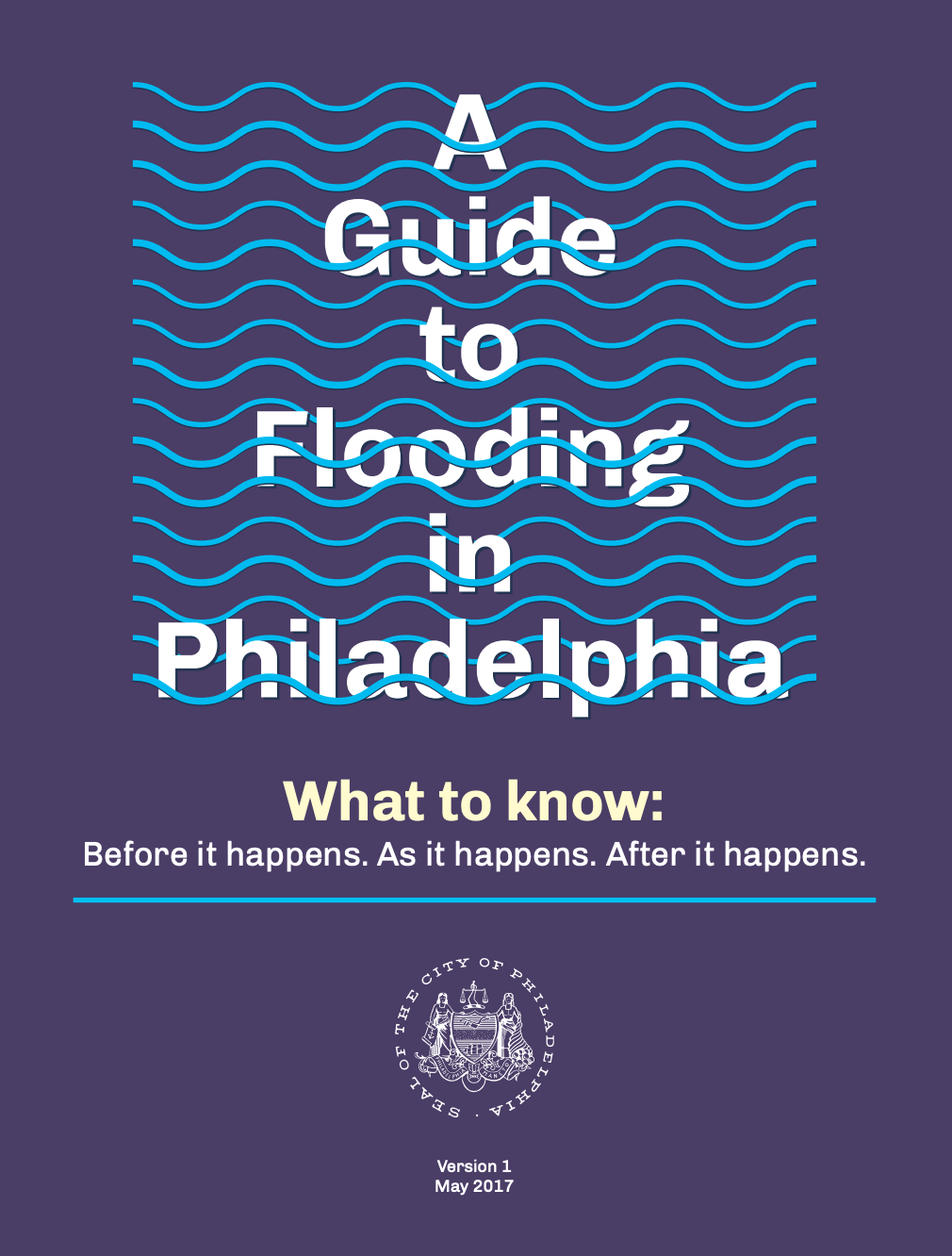
The Philadelphia Citywide Flood Risk Management Task Force is an interdepartmental collaboration that was formed in 2015 as a way to holistically tackle flooding issues across the city of Philadelphia, Pennsylvania. A memorandum of understanding was used to bring eight city departments (Philadelphia Water Department, Philadelphia City Planning Commission, Office of Emergency Management, Office of Sustainability, Philadelphia Streets Department, Philadelphia Parks and Recreation, Licenses and Inspection, and Health Department) and other partners together to address riverine, coastal, and infrastructure-based flooding. The task force was created to leverage the City’s resources and outreach for addressing flooding issues. Goals include increasing inter-agency coordination on citywide and neighborhood-level flood risk management strategies and fostering sustainable, sensible city planning and development.
In 2017, the Task Force released A Guide to Flooding in Philadelphia, an outreach tool directed toward property owners and residents. To further support Task Force goals, in 2018, the City hired its first floodplain manager. More recently, outreach efforts have targeted specific communities prone to flooding, and direct collaboration with impacted communities led to the creation of a neighborhood-led flood risk management task force.
![]()
Consider private-public partnerships as a way to share costs and risk.
While it may not be the right solution for every project, there are times when public-private partnerships provide a unique opportunity to bring high quality and sustainable infrastructure projects to fruition. Such partnerships rely on strong relationships between private and public sectors, drawing on the strengths of each party who share in the cost, maintenance, and overall responsibility, and allow for more ambitious projects to get off the ground due to reliable investments from each entity.
The San Diego County Water Authority (SDCWA) purchases water from the Carlsbad Desalination Plant, which provides the San Diego, California, region with 10 percent of its drinking water needs (about 50 million gallons per day, enough for 400,000 people). The desalination plant, along with a 10-mile conveyance pipeline, was built by Poseidon Water, a water infrastructure development company. The Carlsbad Desalination Plant provides drought-proof and locally controlled water, thus creating a reliable system and water security. A public-private partnership between Poseidon Water and SDCWA has been essential in the success of the desalination plant. The Water Purchase Agreement used between Poseidon Water and SDCWA "assigns appropriate risks to the private sector while keeping costs for water rate payers as low as possible. The agreement transfers to Poseidon and its investors the risks associated with design, construction and operation of the desalination plant." These types of partnership can be an important part of a water management strategy as water resources become more limited and the production of new, local supplies are required to support water supply resiliency efforts (SDCWA 2020).
![]()
For large-scale coastal protection projects, anticipate implementation challenges such as permitting and long-term maintenance agreements, and work with stakeholders and regulating agencies as early in the process as possible to work towards solutions.
Large-scale coastal protection projects often run into implementation challenges related to permitting, maintenance agreements, and cost-share agreements. Anticipating these challenges and working directly with key stakeholders, such as local and state regulating agencies and the United States Army Corps of Engineers (USACE), to address challenges early on is essential to avoid project delays or cancellations.
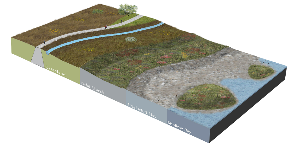
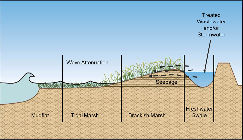
In California, there are currently half a dozen projects attempting to install horizontal levees, a nature-based solution with multiple benefits that include climate resilience, social benefits, and ecological and habitat improvements. The Horizontal levee design combines a levee with a sloped wetland on the waterside, which together act as a storm surge barrier. The sloped land between the levee and the sea provides a space for wetlands to migrate upward as sea levels rise. Many of these projects are designed to use treated wastewater effluent to irrigate the wetland, which provides nutrient removal to improve water quality. Horizontal levees also create additional wildlife habitats and benefit the community when their designs incorporate nature paths and other amenities.
In the City of Hayward, California, the East Bay Dischargers Authority (EBDA), a Joint Powers Public Agency of wastewater agencies in the San Francisco Bay Area, is leading an effort to design and acquire permits for the construction of an innovative, full-scale horizontal levee to build resilience to sea level rise and improve water quality. EBDA is working with several partners, including the Hayward Area Shoreline Planning Agency, on the ambitious First Mile Horizontal Levee Project. In October 2021, a pre-permitting consultation for the project was held to identify and discuss permitting issues, which highlighted a number of areas where regulatory agency feedback is contradictory and/or creates obligations that could make the project infeasible or prohibitively expensive. EBDA is working with local partners and stakeholders to try and address these permitting challenges and seek solutions with policy-makers. For example, the San Francisco Estuary Partnership, another partner on the project, is developing a white paper and workshop process focused on regulatory barriers to the implementation of horizontal levee projects around San Francisco Bay.11
![]()
Footnotes
- Heyn K. 2022 September 25. Personal communication [Personal interview and WUCA member questionnaire].
- Areas or districts that can impose additional regulations based on special characteristics in that zone, such as for natural, historical, or cultural resources protection (Developed from Georgetown Managed Retreat Toolkit).
- Shea P. 2020. August 19. Personal communication [Personal interview].
- An additional amount of height above the Base Flood Elevation used as a factor of safety in determining the level at which a structure's lowest floor must be elevated or floodproofed (Developed from Federal Emergency Management Agency).
- Whitely-Binder L. 2021. September 21. Personal communication [Personal interview].
- Sullivan J & Jewell C. 2020. August 25 and 27. Personal communication [Personal interview].
- Warner J., Zipkin J. 2020, October 23 and 2022, February 21. Personal communication [Personal interview].